| Welcome | Prospects | Projects | Publications | Papers |
| Methods | Purposes | Other | Links |  |
Groundwater Flow from Agricultural Land(An example of developing database expected to be used for agricultural and environmental education) 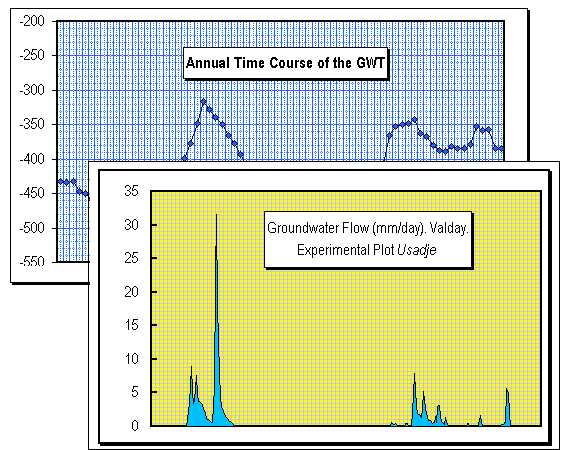 Comment 1 Runoff volume was defined as groundwater flow dominated this area, while overland flow is actually negligible due to well permeable upper soil consisted mainly of light sandy loam. To detect the groundwater flow the plot is equipped with a water level recorder. Water flowing from the plot is collected in a special tube laid under ground at that depth where there is relatively impervious clayey soil horizon (at about 1m depth) then the water flow down into a tank where the "float-and-pulley" water level recorder is installed. The data showed prevalent melt water runoff by a spring, at the end of the snowmelt particularly when water yield from snow comprise both snowmelt and rains falling onto the snow surface. Then, the peak flow is originated from both snow and rainfall that becomes usual for the region over last two decades.
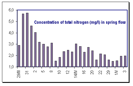 Comment 2 We are able to evaluate the total volume of leaching contaminants such as nitrogen if the data are available on concentration and total runoff volume (runoff depth). Both these have been measured at the experimental plot which places on a hill slope. As one can see, the most considerable runoff volume was observed on late April while the highest nitrogen concentration is at the time when snow barely starts to melt and the water yield (runoff) still is low. While the second peak, plentiful flow, nitrogen concentrations (after some decay) increase again but they do not reach that initial value. The total leaching (outflow) is then defined by runoff volume. Hence, the aim appears to be how to retain that portion of runoff to restrain the contaminant flow. It can be achieved, for instance, by special ploughing of the soil to improve its infiltration capacity. Another way is to retain snow on agricultural field: it is to both prevent surface flow and keep soil water available for crops. Our intentions were to do so and, we were trying to improve the methods for snow management as an agricultural tool. To receive more information, please, apply to |
|
|
|
Hydrosphere © 1990 — 2005 Vladimir A. Shutov |