| Welcome | Prospects | Projects | Publications | Papers |
| Methods | Purposes | Other | Links |  |
Applied Hydrology for Pipeline EngineeringValday Branch of State Hydrological Institute. 175400, Valday, Pobeda Street, 2, Russia. ABSTRACT: Landscape structure and numerical cluster analyses were applied to hydrological regionalization of the environment of a constructed gas pipeline in the North of European Russia. The studies are to improve runoff calculation on the rivers along the pipeline route to mitigate the damage caused by spring floods. As a result the basins are determined to be analogues for ungauged rivers by runoff calculation. Calculations were performed using adopted manuals and detail evaluation of input variables such as snow water content in those basins located on hill uplands. Regional correlation between runoff depth and conditioning factors were obtained for this area. Basic soil water properties were summarized for evaluation of the ground water recharge in areas disturbed by pipeline construction. These include soil water capacities, capillary moisture, water yield and filtration coefficients. Introduction There are very large gas pipelines laid from the rich fields in northern Russia towards its centers of population and industry and further to Europe. They are made of steel pipes about 1,6 m in diameter. The pipeline usually lies under ground where is subject to many natural factors which are hazardous for it and, incidentally for the environment. When the pipeline traverses small rivers and brooks, it can act like a dam due to uncertain prediction of flood water stage. Such cases in wide flat-bottom valleys can lead to inundation of surrounding area. Hence, the urgency of exact calculation of the floods is clear, and is the main objective of the applied hydrology projects. Pipeline can also be an obstacle for the subsurface flow, then disturbances occur in ground water flows. Particularly, the boreal coniferous forests can suffer by this occurrence. Soil cover has particularly been destroyed promoting soil water erosion, either as gully erosion or slow creep. These events are hazards affecting the possible rupture of the pipe. The problem is complex due to coupled influence of surface flow conditions and soil water properties, which depends on geological structures such as moraine sands or clayey deposits. These phenomena are related to the water cycle. The case studies below are to expound upon the methods and results of investigations started five years ago (Shutov and Kapotov, 1996, 1998, 2000). It must be noted that these examples pertain to be applied to other engineering applications. Applied regionalization By landscape analyses five regions have been clearly distinguished along the pipeline route in northern Russia (Shutov and Kapotov, 1998). According to existing summaries (Isachenko and Shlyapnikov, 1989) and our personal experience, they are described as follows: (1) moraine plains of middle-Quaternary age with alluvial lake-glacial lowland plains (appeared intrazonally), (2) upper-Quaternary hills such as the so-called Njandoma upland, (3) limestone karst plateau, (4) near the White Sea littoral lowland and terraces and (5) lake abundant region. Cluster analysis has proficiently been used to choose the representative basins and regions (Shutov and Kapotov, 1998, 2000). The Euclidean metric in multidimensional space of basin attributes was adopted as the measure of similarity. Low Euclidean metric between a pair of compared objects (drainage basins in this case) correspond with high similarity. An improved cluster algorithm was employed. It consists an emergence of the "nucleus" of each class by following transfer of the boundary objects (watersheds) from one class to another to re-evaluate the matrices of similarity to minimize the internal metric for each class (Hosking and Wallis, 1997). The five classes were delimited where the mean degree of similarity varies from 1,13 (2nd region) to 2,61 (5th region). Both cluster and previous landscape analyses provide comparable results. Peculiarities of 3rd and 5th regions are the low spring runoff. This results from the karst in the first case, and from the lake influence in the second. The 4th region abounds in wetlands and it has greatest runoff. The similarity index is reduced by the impact of such regional phenomena. It is lowest of all in the 5th region with large lakes. There is, for instance, the Suma river basin which consisted of a cascade of five lakes that attenuate floods most effectively. Another example of this kind is the basin of the Mosha river. It may be annexed either to 2nd region or to 3rd one, still it is well recognized by landscape structure as an upper-Quaternary hill watershed. Thus, two principles were revealed: (1) some nuclear structure of the regions and (2) non-clear boundaries among them. Obviously, if the classifying basins are numerous, then the regions could be defined more definitively by involving some additional attributes (signs). We proffered to use the so-called belt-diagram (Shutov and Kapotov, 1998) which allow to reveal those basin attributes definitive for a given region. These attributes are physiographic and hydrological parameters of the basins. Such a belt-diagram is to display the hydrological properties of the pipeline route as understandable for decision makers. Spring Runoff Calculation and Forecasting Calculations of spring runoff proceed usually (Flood flow computation, 1978) from the principles of mapped runoff depth and spatial reduction of peak flow with the use of following parameters: runoff depth (mm) mapped relied upon historical data, empirical form-parameter or index of "sharpness" of flood hydrograph, factors conditioned by lakes, sandy soil and wetland partial areas respectively, total area of the basin, and an empirical exponent. Such a simple procedure is because of previously developed relationships and algorithms. For instance, runoff depth values have been re-evaluated using fresh regional observation data. Improvements can also be achieved through examination of empirical relationships between runoff depth and physiographic factors such as elevation or sandy soil fraction areas. The key factor of "sharpness" has been defined by observation in above mentioned model (analogue) basins. 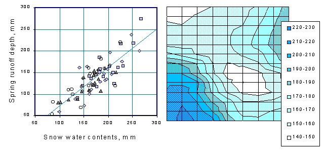 Figure 1. Spring runoff conditions in northern Russia Left: Empirical correlation between runoff depth and snow water content for four watersheds Right: Spatial distribution of runoff depth (mm) calculated for the area (cell is 10 x 15 km) Current spring flow forecasting have been carried out after end of winter snow surveys. These input data (Figure 1) should be prepared by spatial averaging. Interpolation was carried out using empirical relationships between snow water content and elevation (Shutov, 1998). A method to forecast flow consists of developing an empirical correlation between runoff and snow water equivalent or sum of winter and spring precipitation amount. In northern areas of Russia these dependencies are linear and stronger than in other regions, but they should be complemented with estimates of infiltration capacity of frozen soils. The latter strongly depends on soil textural types and soil frost depth, varies spatially so as the snow depth does. The key problem appears to be again of how to retrieve the snow cover distribution as correctly as possible. Soil physical properties The spring flood is the period in which the ground water resources are changeable and augmented significantly. They may be defined either from the water balance equation or by using the data on ground water table. Generally, the ground water recharge (mm) is calculated through the water yield coefficient of the aquifer and-time change of the ground water table (cm). When some disturbances occur in flow conditions, the ground water recharge will also be affected. The exchange between subsurface and stream flow depends on the hydraulic conductivity of soils, which can affect feeding the stream or, in opposite, some return from it, by back-slope inclined water table. The first case takes place in the uplands during the snow melt period. The second case is especially common for valleys especially composed of alluvial sands. Ground water recharge during spring flood can be almost equal to the runoff. Hence, it is to be evaluated correctly by using the data on ground water level and soil water properties. Soil water content may increase up to saturation moisture (SM), then it decreases to field capacity (FC) by gravity drainage due to percolation into the deep subsoil. Later there are evaporation losses from the surface. This component of the water cycle can also differ by lying a pipe. The disturbances will be considered just in the North. The capillary moisture (CM) is an index when the water fills only fine capillary pores and the coarse pores are empty due to vertical drainage. The destruction of upper soil and its porous medium causes the disturbance in natural drainage so, estimation of the water yield should be necessary based upon the water capacity was carried out either as (SM - FC) or as (SM - CM). The first expression belongs to a sandy soil, the second to a sandy loam and silt loam. The latter is to be advised preferably, since the loamy sub-soils prevail in the deep ditches excavated for the pipeline. The water yield values were fitted for all the soil types encountered along the pipeline route. To achieve this we used (Kapotov et al., 1996) the close empirical correlation between capillary moisture (CM) and bulk density for the soils of various textural types (Figure 2). 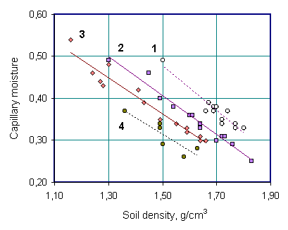 Figure 2. Capillary moisture (volumetric) in relation to soil density for various soil textures: 1 - Sandy soils, 2 - Sandy loam, 3 - Light silt loam, 4 - Silt loam on clay Conclusions Proceeding from the analysis, we found along gas pipeline routes the certain sections with environmental hazards. These were recommended for special field investigations prior to the pipeline construction, they are: (1) route segment that passed over karst regions in the Dvina and Onega river basins; (2) cross-section of the wetland landscapes with numerous lakes near the White Sea shore; (3) relatively large rivers such as Vel' and Mosha with their wide, flat and forested valleys. Many of the environmental extremes concentrated at those sections of the pipeline which are subject to flooding. Another hazardous phenomena is the ability of saturated and frozen ground to creep down-slope under load. Permanent factor actual to north region is that the forest ecosystems suffer impacted by construction due to disturbance in ground water flow. References
|
|
|
|
Hydrosphere © 1990 — 2005 Vladimir A. Shutov |