| Welcome | Prospects | Projects | Publications | Papers |
| Methods | Purposes | Other | Links |  |
Improvements in spring runoff calculation for the Belaja river basin (South Urals Mountains)Valday Branch of State Hydrological Institute. 175400, Valday, Pobeda Street, 2, Russia. There is a problem of how to predict flood runoff as correctly as possible for those rivers which are situated partially in mountains with no precipitation gauges. The river Belaja has such a drainage basin: its area (120 000 km2) lies in South Urals at elevations ranged from 200-300 to 1600 m. That part of the basin in mountains (Figure) is poorly enlightened with precipitation measurement data and, therefore, runoff from this area is unpredictable or predicting inaccurately. However, the floods occurred on the basin damage the area down-stream where there are great population (the Ufa city has nearly 1,5 million peoples) and industry plants as well as large infrastructure objects. Hence, we would have been made efforts for detail investigation of snow cover to provide a more realistic forecasts (Shutov and Kaljuzhny, 1997). Analyzing upon long-term precipitation data of the network existed, we have distinguished nine regions with individual relationships between winter precipitation amount and elevation (or with no correlation among them). Region boundaries were delimited by structure of mountain ridges and directions of prevailed wind. Based on water balance approach the snow drifting and snow accumulation rates have been evaluated. An example where five of the nine regions are revealed, one can see in Figure. Regional precipitation - elevation dependencies were found there. For this area the precipitation map was drawn using received elevation dependencies as proffered earlier (Shutov, 1996). These improvements gave an accurate input for evaluation of actual snow water equivalent and, respectively, runoff depth in the mountainous part of the basin. 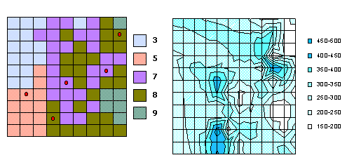 Figure. Analysis of winter precipitation in a low mountainous area Left: regions delimited within a part of the Belaja river basin (points show observation sites) Right: precipitation amounts (mm) interpolated with allowance for elevation References
|
|
|
|
Hydrosphere © 1990 — 2005 Vladimir A. Shutov |