| Welcome | Prospects | Projects | Publications | Papers |
| Methods | Purposes | Other | Links |  |
On the INFOMAP analysis of snow cover spatial distributionValday Branch of State Hydrological Institute. 175400, Valday, Pobeda Street, 2, Russia. The author devised an original method so-called "informative-mapping analysis" (INFOMAP) (Shutov, 1990, 1994, 1999, 2000). This method was developed from the data of detail snow survey on small watersheds. As was found, the local scale snow distribution displays quite evidently the spatial patterns repeated every year (Figure 1). Snow concentrates mainly in hollows, valleys, bushes and at a forest edge. Less snow water content is observed near the watershed boundaries and on wind-exposed slopes of the hills. 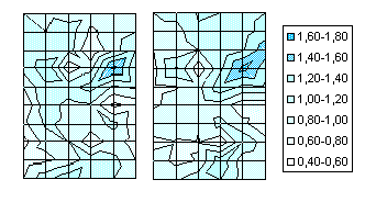 It is hardly to evaluate an individual effect of each snow accumulation factor, since they affect simultaneously. It seems to be more reasonable to arrange different topographic and landscape elements according to the local snow accumulation coefficient (LSAC) which is the ratio of "at-cell" value of snow water content and its average evaluated by a representative survey. Then, each specified cell of the surface has been described by a number of signs (indices) of snow accumulation. These signs have been collected into four groups attributed relief, exposure, plant cover and forest types. Inside each group each index is ranking as a digit M from 5 to 1 in accordance with snow retarding capacity of the cell: 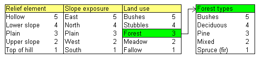 We can easily show that the mean value of sign reflects the probability of maximum snow retention (or maximum LSAC) on specified cell. It was rendered by classical Shannon's definition of the entropy as the measure of information which is proportional to binary logarithm of mean rank value. In other words, the information on snow water equivalent for each cell depends on binary logarithm of mean value of the sings reside in the cell, i.e. relief, exposure, land use and (in addition) forest types. Simple empirical equations based upon this background were obtained by observation. These are empirically expressed as follows: LSAC = 0,375 Log (M) + 0,50 and LSAC = 0,235 Log (M) + 0,65 where the first equation belongs to a field (open) area, the second one to mainly coniferous forest. The correlation coefficient of represented relationships is equal to 0,82-0,84. An example of INFOMAP analysis for a fraction of real watershed is given in Figure 2. 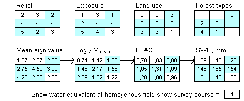 Figure 2. An example of INFOMAP analysis for a part of a drainage basin Significant biases detected in respective empirical scatter plots originate from remained uncertainties. To diminish them, we have to assume in addition such "dynamic" signs as wind direction mainly affected snow drifting. By this, the model would have dynamic component and therefore not to be static and speculative in changing climate. References
[an error occurred while processing this directive] |
|
|
|
Hydrosphere © 1990 — 2005 Vladimir A. Shutov |