| Welcome | Prospects | Projects | Publications | Papers |
| Methods | Purposes | Other | Links |  |
Joint PDF of Soil Physical Properties Responsible for Runoff and Ground Water RechargeValday Branch of State Hydrological Institute. 175400, Valday, Pobeda Street, 2, Russia. Investigations have been done at Valday Hills, an area in northwestern Russia, of soil physical properties in particular to found, what consequences can be resulted from the natural variability related to infiltration, surface runoff and ground water recharge. Experimental watershed Usadjevski Log (about 0,45 km2) composed mainly of two-layered soils (sandy loam on silt) inherent to the region serves as the study object for a long time. It is gauged of raingauge with the double fence protection, rainfall recorder (pluviograph), staple snow survey courses, the hydrometrical so-called V-notch weir at the outlet, 11 wells for ground water observations drilled into an upper Quaternary aquifer, 16 sites for soil moisture measurements conducted by neutron probe method. All the observation data are used by water cycle investigations, for instance, for soil water budget (Kapotov and Shutov, 1993), snow water contents (Shutov, 1998a) and the surface (overland) flow (Shutov, 1996, 1998b). Soil cores were taken in cells each 100x100 m of a regular grid and, three soil columns have been dug out at three sites corresponding to prevailed soil textural types. The data on the soil properties (soil density, water capacity, filtration coefficient and hydraulic conductivity) obtained as a result of laboratory investigations were approximated by both empirical and theoretically based equations to get a three-dimensional picture of soil cover (Shutov and Kaljuzny, 1994). Spatial distribution of soil thermal properties was studied earlier (Shutov and Belolutskaja, 1990) as well as conditions of melt water infiltration. The following criteria were chosen to characterize the water exchange and surface flow:
We investigated the spatial distribution of these features in relates to the surface relief, land use and vegetation (Figure 1). The areas were found where either infiltration or surface flow are prevailed by various rainfall intensity. This reflects the soil non-homogeneity and, on the other hand, they result in variability of ground water recharge and, consequently, of ground water pollution and impact on ground water regime by any construction. 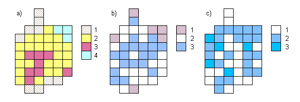 Figure 1. Spatial distribution of soil physical properties of the Usadjevsky Log watershed
Studies in stochastic behavior of soil properties (Shutov, 1996) were the next step which is to develop models for runoff generation and ground water recharge, because of random variable quite corresponds to the natural conditions as distributed randomly at local scale. We try to develop this stochastic approach as compatible with a deterministic model based, for instance, on modernized Green-Ampt equation (Schmidt, 1990). Thus, we are able to estimate so-called runoff creative potential which can serve as input for the ground water recharge. The most trivial way to introduce spatial distribution as a stochastic issue is the synthesis of joint (multi-variate) probability density function (PDF) of point values of those properties which defined flow such as soil water deficit DW and filtration coefficient K. This function P(DW, K) can serve as one of the parameters in a new model for overland flow and ground water recharge. By statistical independence of DW and K their joint PDF may be composed by multiplying the corresponding PDF, i.e. Pm = P(DW)P(K). If DW and K values are correlated, then the components of their covariation matrix must be introduced. If separate (marginal) statistical distributions are non-gaussian, then such an analytical composition of joint PDF appears to be too complicated, and it has to be tabulated, or to be fitted as the known expression for PDF, such as, for instance, log-normal distribution (Ludwig and Reynolds, 1988) admissible as a first step. Combinatory statistics of the basic soil physical parameters are available to evaluate the runoff creating area as probabilistic function (Figure 2) of DW and K. Then, it needs to discover, whether it may assume them independent and what is their statistical distributions. We found the empirical joint probability density function (PDF) as having two nuclei or two unequal domains of high frequency: the major nucleus characterizes the spatially distributed input into the ground water, the secondary, as it seems, is responsible for surface runoff generation. 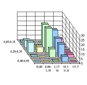 Calculation of the surface flow and infiltration into the ground water were performed by using modified Green-Ampt equation with taken into account the above bi-variate PDF of soil properties and the value of capillary pressure at the wetting front defined by pore sizes. By such a way the examined small watershed was subdivided onto at least three areas: (1) where the surface flow can always be, (2) where, in opposite, the ground water inflow takes place, and (3) where either runoff or inflow are prevailed by turns, by heavy shower or by slow rains. Soil water residence time (SWRT) is another significant issue to govern the vertical water exchange in unsaturated zone and transfer of contaminants to the ground water. It may be defined approximately as the ratio of water content within a soil column and hydraulic conductivity for underlying horizon. Using the soil water properties the frequency curves of SWRT were received and approximated (Shutov, 1998b). As was found, they are irregular for those soils which are of two-layered sandy loam on silt (Figure 3). SWRT values vary for space from a few hours to about one month. This affects spatial variability of runoff conditions and ground water recharge. 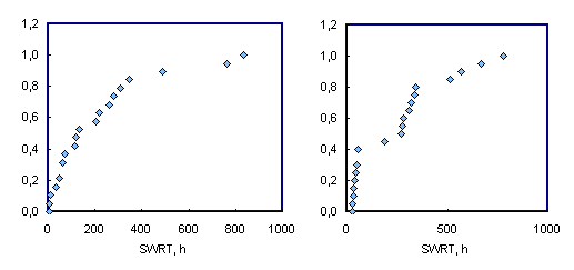 Figure 3. Cumulative frequency functions of the soil water residence time (SWRT) for two soil profiles: homogenous (a) and two-layered soil (b) Stochastic behavior of soil water properties entails dispersion of contaminants within unsaturated soil (Wallach and van Genuchten, 1990). There are two problems: the first is how to examine a peculiar character of subsurface flow and dispersion within two-layered soils frequent for post-glacial landscapes, the second is how to make comparable those properties field-measured and studied laboratory. It needs to obtain in conjoint form the interlacing soil properties such as grain size, soil density, effective porosity, water capacity, water retention, permeability, and dispersion parameter of spatial heterogeneity, and the same features for seasonally frozen soils as well. We describe these features analytically to embed them into the model. There are the problem of how to re-evaluate the data given at a point (soil column) to the watershed scale. We proffer to correlate them with relief elements, soil texture and genetic types, etc. Generally it must be convenient for soil physics, hydrology and statistics to approach the simulation model. One needs to be artful to ascertain the links between statistics of input (soil properties) and variability of output (surface runoff generation and ground water recharge). Combining this empirical basis and the ideas on runoff generation and the physical-chemical interaction, we can advance towards understanding processes of the ground water quality formation. Thus, the concrete targets which seems to be now affirm in front of our explorations are as follows:
The latter two are not satisfactory resolved at this time, so they must be the key problems to a future research project. Hence, the fundamentals should be:
We suppose to enhance predictive ability of the local scale model through a spatially common performance based on wide geographic summary of soil properties including those modified by agriculture and land use. Landscape analysis and regionalization have to be made to identify those areas supposed homogeneous. There are long-term time series of hydrological variables that allow us to use the multivariate statistical approaches (Ludwig and Reynolds, 1988). Hence, the stochastic models can be used preferably, i.e. ground water quality may be predict as probabilistic terms, that is useful to plan the water protection in changing climate. References
[an error occurred while processing this directive] |
|
|
|
Hydrosphere © 1990 — 2005 Vladimir A. Shutov |