| Welcome | Prospects | Projects | Publications | Papers |
| Methods | Purposes | Other | Links |  |
Snow spatial distribution at a local scaleAs it was mentioned above, the macro-relief is important to regulate precipitation both in summer and in winter times. Influence of the Valday Hills situated in north-west of Russia on snow cover distribution (Figure 4) has been discovered by analysis of the experimental snow survey data obtained by special dense network. 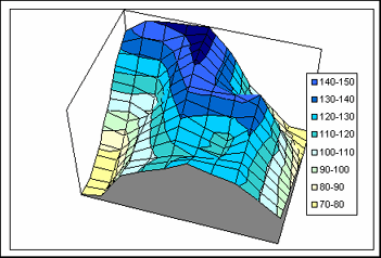 Figure 4. Conventional "relief" of snow water equivalent over the Valday Hills There is the snow abundance revealed clearly in the Polomet' river basin about 2000 km2 in area that overlaps different elevation zones of the hills from 290 m to 40-50 m a.s.l.. It may affirm by analyzing the observation data that: 1) snow water equivalent at an open area Ho closely depends on elevation, 2) the ratios of Kf = Hf / Ho (where Hf is snow water equivalent under a forest canopy) vary for different forest types. These issues give a possibility to obtain a more detail snow cover distribution over river basins contrary to the received by simple interpolation of the standard survey data. Excluding mountainous terrain, the relationships between snow water equivalent and elevation are not taken into account as usual. By this, the possible water yield for spring runoff generation is underestimated. Hydrologists encounter similar conditions while all the hilly areas of European Russia. Hence, the snow water equivalents should be interpolated by two-step procedure (Figure 5) that makes an allowance for more reliable warning of floods for a number of ungauged rivers. 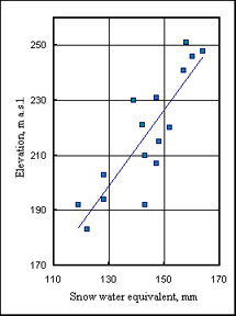 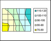 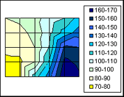
Figure 5. Snow water equivalent as affected by elevation of terrain Interpolation of the data from only surrounding meteorological stations results in an even spatial picture of the snow cover. Insert of the experimental data gives much more detail field of snow water equivalent. Moreover, the spatially averaged Ho-values increase from 100 to 170 mm. The latter value is quite differ from adopted spatial means, that is ordinary for hilly uplands and, despite, negligible presently by making a spring runoff forecasts. Hence, it follows the necessity to estimate the altitudinal gradient to comply all the snow cover maps with it, especially for those regions of longitudinally oriented low mountain ridges and uplands such as the Urals, Valday Hills and so on. The local or "subgrid" variations in snow water equivalent describes usually by so-called cumulative frequency curve and variation coefficient Cv which is the ratio of standard deviation and the mean value. As was found by snow survey data, it changes from 0.08 to 0.85 related to its averages. This dependence is of very interest to interpret the data of remote sensing of snow cover especially for a complex rugged terrain. A variable snow cover influences the snowmelt intensity so that outweighs many of other uncertainties in snow cover monitoring. Spatial variation of snow under forest canopy is less than on a field (open) areas. Initial snowfalls in December provide about 60 mm, thereafter the continuous snow cover occurs under trees, while open hills stay still no snow due to snow drifting into hollows. Experimentally derived snow coverage curve is used to estimate the snow covered area (FS) or in opposite no snow area. The FS-curve (Figure 6, right) defines also the so-called snow depletion curve which determines the area of simultaneous snowmelt in river drainage basin, or over a flooding area. The empirical coverage curves for woody catchment was approximated as cubic power expression. 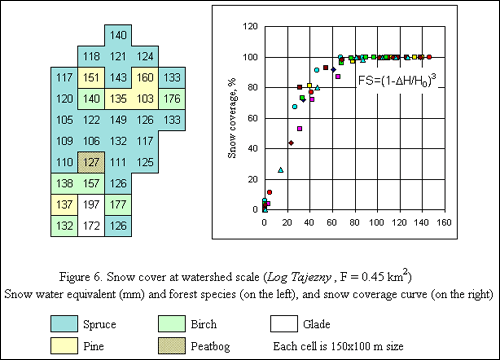 Figure 6. Snow cover at watershed scale (Log Tajezny, F = 0.45 km2) There is a question, how such a sub-grid variability may be transformed to more regular spatial picture of snow cover in a macro-scale drainage basin with rugged relief, i.e. what the interrelations are among snow distributions of different scales. We discovered an elusive border between micro- and macro-scale spatial patterns of snow cover to recognize this. To achieve this aim, we are inquisitive to an in-situ obtained data and we derived the snow cover survey of the finest spatial resolution. This is a survey over a plot 2,5x2,5 km2 with 100x100 m spatial resolution. There is perceptible elevation ascent from 110 to about 260 m which overlays the mosaic quasi-random spatial variability of snow. Spatial averaging with a coarse grid discovers the peculiarities conditioned by Valday Hills as a whole. Thus, stochastic (random) and deterministic behavior of snow cover depths can be compared. This is an empirical ground to simulate multi-scale snow fields under the so-called auto-model or fractal concept
and to retrieve such a sub-grid distribution by remote sensing data.
|
|
|
|
Hydrosphere © 1990 — 2005 Vladimir A. Shutov |