| Welcome | Prospects | Projects | Publications | Papers |
| Methods | Purposes | Other | Links |  |
Statistical properties of rainfall fields as applied to satellite-based precipitation estimatesValday Branch of State Hydrological Institute. 175400, Valday, Pobeda Street, 2, Russia. Extended abstract of the annual study report A circumstantial summary of radar precipitation measurements has been developed as applied to the problem of validation of the satellite-based rainfall estimates. Results of the secondary calibration (testing) of the weather radar are expounded briefly. Special algorithms were pro-posed which are necessary for statistical data treatment provided with relevant case studies. The rainfall fields are classified objectively corresponding to their synoptic origins. Basic features of the rainfall fields have been analyzed: the spatial coverage coefficient (SCC) and spatial reduction factor (SRF). In particular, the relationships have been obtained between spatially averaged precipitation amount and the SCC, these are to improve remote sensing retrieval algorithms. Spatial and temporal reduction phenomena are explained based upon a few examples and described statistically through the frequency distributions of the SCCs and SRFs. As to the SCC statistics (see Figure 1), they demonstrate quite distinctive differences for slightly different spatial scales: from 1000 to 4000 km2. 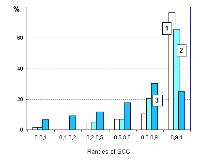 Figure 1. Frequency (%) of the SCC ranges for three spatial scales: 1 - 1000 km2, 2 - 2000 km2, 3 - 4000 km2 Two statistical models constructed using more than 300 individual rainfall fields are ex-amined: (1) conventional probability density function (PDF) for "at-cell" and spatially aver-aged rainfall rates and (2) the Poisson distribution function for the discrete (quantized) values. The latter allows to estimate probability of the events when the rainfall rates exceed some "threshold" values as well as the probability of the times elapsed between such events. Quantization of precipitation amounts to be described as a "flux" of discrete events ap-pears to be a problem: when the aim is to reflect climate-related variability, we have to evalu-ate the threshold as climatically defined. For instance, we should examine the rainfall amounts of ascertained probability, evaluated by long term data series. High precipitation would appear as sparsely distributed "cores" on individual field dia-grams (see Figure 2). Statistically, it could be described through PDF of a particular SCC. So, all the above approaches are inter-connected. 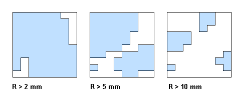 Figure 2. The diagram explained on what the spatial reduction of precipitation amount is and, simultaneously, on how to discretize precipitation fields using at-cell "threshold" values Particular attention has been paid for the spatial structure of rainfall fields described using the variogram or, say else, structural function (SF). The SFs have been studied for two synoptic types of precipitation: frontal rains and air mass (convective) rainstorms. In the latter case, there is an anisotropy in latitudinal and longitudinal SFs (see Figure 3) that could be due to influence of the local relief (the Valday Hills extended generally north to south).  Figure 3. An example of spatial SF for mainly convective precipitation The latitudinal SF (above) and the longitudinal one (below curve) Noteworthy is that empirical SFs are subject to power function by their analytical approximation. This fact testifies the "fractal" nature of rainfall fields, i.e. the properties of the field determined at different spatial scales are self-similar. The self-similarity are inherent in the structure of rainfall that allows to use the fractal theory to simulate aggregation of clouds and variability of rainstorm rates. Such models are of particular value for an area where rain gauge network is not enough. Recent publication Shutov, V.A. (2002). Conceptual basis for the use of radar and hydro-physical data in operational and engineering hydrology. - Meteorol. and Hydrol., No. 7, pp. 57-70 (in Russian) |
|
|
|
Hydrosphere © 1990 — 2005 Vladimir A. Shutov |