| Welcome | Prospects | Projects | Publications | Papers |
| Methods | Purposes | Other | Links |  |
Spring flowField investigations of the spring flow The runoff studies are being continued to both fundamentals and applications. Three main study sites of the Valday Branch of the State Hydrological Institute are:
Earlier, there have been in operation a number of research watersheds, many of them are of unique locations and aimed at unique purposes. For instance, the Sinja Gnilka (for Russian "Deep Blue Clay"): small watershed of a brook which was afforested by pine still in early 1950s. The goal was to monitor the changes of the water regime due to impact of growing trees. Originator of the project, Prof. Fedorov is now recognized as the leader of the so-called "Forest Hydrology" in Russia. His book about the forest hydrology studies is being translated in English.
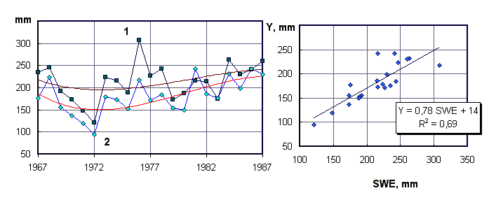
Observed flow from small research watersheds allow to reveal trends related to the climate changes and to the human impact such as de-forestation, agriculture, construction of the road or pipeline, etc. One of the study results shown in the below Figure belongs to the small grassland watershed Log Usadjevsky. Left panel of the Figure shows an evident increase in both total water yield from snow and rainfall water (SWE+P) and stream runoff (Y). The right panel demonstrates the close correlation between runoff and SWE. The same relationships drawn for many drainage basins are to predict flood flow by using the snow survey data on which methodology the site visitors can be posted when looking here at the Snow Book.
How renew and develop the experimental investigations was one of the goal of the meeting Valday-2003 recently held at our site. And, what is new in the applied hydrology studies aimed to support decisions by pipeline engineering and protection against flooding?
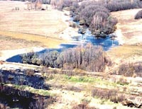
The Great Watershed is the border divided the drainage basins of great Russian rivers and, simultaneously, the basins of three seas: the Baltic (the West Dvina river flowing westwards), the Caspian Sea (the greatest Russian river Volga and its tributaries), and the Black Sea (of which basins the Dnieper is started here). How looks the area at early spring time just after snowmelt, you can imagine by the below Picture made from a "bird eye", by a helicopter flight we taking there to observe the situation with flooding along the gas pipeline route. Of course, we were not only delighted of vistas, but toilsome by soil moisture sampling with manual bore. Probably, this field season would be fruitful of data sampled. |
|
|
|
Hydrosphere © 1990 — 2005 Vladimir A. Shutov |
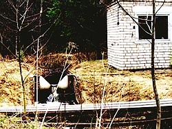 Each of the small experimental catchment is equipped with the so-called V-notch weir to measure water flow of the stream. It looks as shown in the next Photo.
 Early spring of the year has allowed us to explore an area situated at the "Great Watershed" near the town of Rzhev, Tver' region, some 250 km west of the Moscow city.