| Welcome | Prospects | Projects | Publications | Papers |
| Methods | Purposes | Other | Links |  |
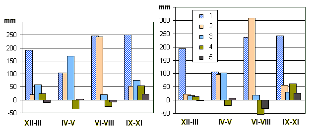
How we can affect the water cycle?An inquisitive school student, probably, a future scholar and, as such - my colleague (and, maybe co-author of my future works! Why not?) has stupefied (and enchanted) me with emailing this question. I shall try to answer it through the web-site and address other relevant issues. The question allows for a variety of answers, because it comprises an ambiguity. What do we mean by the "water cycle"? There is one sense if we tell about the water cycle at global scale, and there is quite another when we are going to tell about local water cycle, the "water balance" at a watershed scale (you must have known what the "watershed" means, that area for which we imply the water cycle closed, from rainfall to runoff at the basin outlet). We also should bear in mind the water cycle and its several "gears" such as precipitation, evaporation, ground water flow, etc. are physical phenomena, but the water balance and its several components are only "sensible" mani-festations of the water cycle. We are able to evaluate, in dependence on our sensors' capabilities, only several discontinuous components trying to quantify the water cycle. We thus "alienate" sev-eral components from their continuity when measure. Though, this is a "philosophy", and you could say that I avoid the direct query. But, the rig-orous philosophy provides incentives to more thorough studies. So, we should not identify every observed change in the water cycle as a real human impact on it. When finding a time, I would tell about the global scale water cycle and place the essay onto my page. Oh, there could be a lot of intriguing stories about how the mankind affects our planet's atmosphere, surface, vegetation cover, etc. that is affecting the water cycle. I would only say that the local scale changes when being added may become "quasi-global". True global are the human impacts on the climate, and there would be a significant impact on the water cycle through the climate change. Some problems were slightly touched upon in my brief story about the LSP (Land Surface Parametrization) schemes for the GSMs (Global Climate Models). As to a local scale, by remembering our history (the 1950-60s) we reveal sensible regional ef-fects on the water cycle on the so-called "Tselina" (stress the last syllable as for French words) which is a tillage of formerly virgin lands all over northern Kazakhstan prairies. Ploughed were about 250 millions of acres where the water cycle has been affected due mainly to increasing melt water flow (overland flow down a slope) by spring time that in turn provokes the soil erosion and lost of its fertility. Through an increase in evaporation from agricultural plants, the total (stream) runoff has, as many of observations have attested, been reduced. Since, the 1970-80s, many lead-ing farmers and professors of agrarian science have proffered to apply a variety of soil protective practices. Of these, I should tell (as being involved by that time) about the snow management and the SPCA (Soil Protective Contour Agriculture). Since the early 1990s, we observe such a regional-scale impact on the water cycle grows weak due to Russian economic crisis . While the crisis is already over, we shall return to the water- and soil protective agriculture else there would be the same that endan-gered Great Plains during the 1920s (remember the "Dust Bowl"). Formerly, by the Soviet Union we have provided a great impact on the stream runoff through the large dam construction for hydro power. Most of the great rivers such as Volga, Dnieper (both are in Europe), Ob', Enissey and Angara (these are Siberian) were dammed and become cascades of large reservoirs. These are as areally extended as some of the great lakes, for instance, the larg-est reservoir on the Volga river is almost equal (7,900 km2) to ? of Lake Ontario. Exploited res-ervoirs have greatly affected local climate, changing the areal precipitation and usually increasing evaporation which, as was found, can be about as twice greater of that for land surface. The same is to be said about the largest, Fos do Iguasu in Brazil. The greatest reservoirs in China, as it seems, affect more slightly because of their location, mainly within deep and narrow gaps. By now, new large hydro power projects are realized such as recently constructed dam at the Bureja river (Russian Far East). And, on the other hand, many suggest the old reservoirs would become danger if their dams will be ineffective. There appears a new challenge: how to strengthen and make them reliably. The dam safety has, for instance, been a problem during the Hydroproject seminar held on last March. Also, a particular problem is how to reliably evaluate the evaporation from great reservoirs. That method adopted, based upon Penman's equation is ineffective for a waving water. Requested are the technique and approach used in marine research. Of the locally manifested, there are special effects due to large underground pipelines. When a big pipe (up to 1.6 m in diameter) is laid under ground it does restrain the ground water flows. This is mainly observed throughout those areas of shallow ground water table (shallow "aquifers" as geologists say). There is also decreasing evaporation because of boreal forest is cut down by construction and transportation (transient roads). The problem appears how to make impossible, or even though mitigate, the impact which entails technogeneous wetlands. To a conclusion we arrive, there are two ways of affecting the water cycle: (1) global scale effect, mainly due to an impact on climate and (2) regional or local scale effects due to various business activity. Global human effect is areally diffused, slowly revealed, only for decades. On the contrary, the local effects on the water cycle are much more expressive, their areal extent de-pends on what is going on: either, for instance, construction of large dams creating reservoirs, or local water intake, e.g. for water supply for a small rural community. We should also emphasize that changes in the water cycle may occur mainly through the sur-face evaporation (or evapotranspiration, if there is a plant cover) and surface runoff, exactly the partitioning flows between the surface and underground due to an influence on infiltration capac-ity of the soil. But, there is practically no effect on precipitation amount and deep ground water reserves, except for such a situation as in surroundings of a deep coal mine. As an example, we could infer about the influence of irrigation. It affects local water cycle through the following mechanism: increasing the soil moisture content - increasing evapotranspi-ration - uprising the ground water table (GWT). Increased evaporation originated by both transpi-ration activity of growing crops and, that is important, additional energy input due to decreased albedo (solar radiation reflectance) of the wet surface. Runoff is less affected due to opposed in-fluences of evaporation and GWT. Irrigation scheduling requires therefore a set of data on the wa-ter cycle components as well as diagnostic weather conditions. On the problem stated, we expound through the energy budget approach that was used by de-velopment of the Automated System for Data Sampling and Assimilation (ASDSA). One more affair which would probably entail a quasi-global effect is cutting the tropical rain forests that violates the water cycle for a good piece of South America. Some effect of this kind we observe here in Russian forest zone. It could be exemplified by two diagrams which show the basic water cycle components for small watersheds at Valday, one (on the left panel) open grass-land another (on the right) forested with fir (spruce).
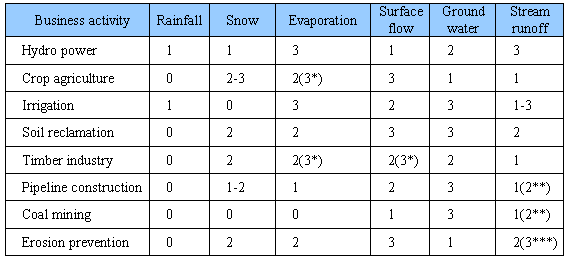
The diagrams have been resulted from an analysis of long-term observations at Valday Hills, Russia and are one of the outcomes (slightly simplified to a broad audience) from our recent study of water balance (see here at index.shtml). By looking at the image, one can reveal a dramatically changed evaporation during summer particularly. This is due to transpiration of trees which is a considerable part of total evaporative losses. Complete cutting the forest entails about 30% de-crease in evaporation so the soil moisture content becomes greater that creates wetland shrubs in place of coniferous wood. This would occur in spite of the runoff from an open watershed is ap-parently higher, by spring snow melt in particular. But, it often does not increase after cutting in realty where, as west of the Valday Hills, the land surface is generally plain lowland. There is no doubt, these inferences are broadly applicable, first of all to plan for timber pro-duction which is a profitable business here providing job for many of local peoples. The above was an example of evident human impacts, but they can be inadvertent. So, going to reclaim wetlands for crop agriculture, we affect the GWT and soil moisture through either open canals or underground drainage and often doing so heavy that greatly affects runoff of the local streams which are fed from the wetlands. Drained boreal wetlands (such as in north-western Rus-sia) are as usual less runoff productive than those remained intact. But, when drained are the low-land swamps fed by both rainfall and deeper ground water, the stream runoff increases due to an additional water intake from beneath. This often occurs in Polesje, a wetland abounded region of Belorussia. By affecting evaporation, the agricultural drainage can entail water deficit, an artificial "drought" when irrigation will already be needed during several time intervals crucial for crops. In this case, it is better to use the so-called double-active tile drainage. Considering all the above mentioned, we can draw a table (matrix) which is to appraise how much the human impact on the water cycle is.
The digital ranks serve as expert appraisal of the effects: 0 - no impact, 1 - slightly percepti-ble, 2 - significant, 3 - great impact; double digits with * are when the business is more intensive or less "nature-friendly", ** signs an intensive impact on small rivers, *** is for only those "dell" brooks which drains the watersheds under impact. Of course, the estimates are depending on what the affected area is, what a landscape is prevailed and so on. So, crop irrigation can affect runoff either slightly, when there is no water intake from rivers, or even largely. I plan for improving the conventional (as well as disputable) appraisal and would greatly ap-preciate everybody helping with an expertise based upon a local practice. I also think this would be a useful and inexpensive tool for planning applied research. |
|
|
|
Hydrosphere © 1990 — 2005 Vladimir A. Shutov |